Using ScanLook on the Water
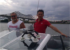
Using ScanLook on a waterway can be identical to scanning from a ground vehicle. If the boat can be kept still for upwards of one minute then it is the same. Alternatively, if the boat can move fast enough then it is possible to perform a kinematic alignment for initialization. If this is not possible (because you are on a large, slow ship) then a dual–antenna system may be necessary. Generally a ship is not used as a scanning platform. Nevertheless, ScanLook can be adapted to support a second antenna but this should be done prior to purchasing to avoid shipping the unit back for the necessary modifications.
Often times on the water it is possible to work without ever losing GPS lock. This enables the use of PPP post–processing methods. This gives the added benefit of getting base station quality results without the use of a base station of any type. Obviously this would be to great advantage in a large swamp or when scanning an off–shore platform of any sort.
While NovAtel’s IE software does support PPP processing, TerraPos is generally the leader in this area of processing. Stay tuned though as things change over time.
For more information on PPP visit these links:
http://www.frontiergeomatics.com/7_terrapos.html,
http://www.frontiergeomatics.com/docs/Ovstedal_et_al.pdf,
http://www.terrapos.no/index.html